
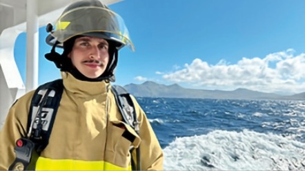
Rob Sobelsohn ’19 is helping to plot the ocean floor as an ensign for the NOAA Commissioned Officer Corps.
Ensign Rob Sobelsohn ’19 of the National Oceanic and Atmospheric Administration (NOAA) Commissioned Officer Corps typically begins his day at the bridge of the NOAA Ship Fairweather, piloting the 231-foot research craft over uncharted seas off the southern coast of Alaska.
Sobelsohn and the crew of the Fairweather are currently plotting the marine floor of the U.S. Exclusive Economic Zone (EEZ) waters, which extend up to 200 miles from shore, revealing geographic features and gathering data in areas that have yet to be fully explored. “In uncharted waters, we have no idea what the soundings are, or what the rock formations are down below. We’re putting that information in the chart for the first time,” says Sobelsohn, who majored in environmental geography at Colgate. “It’s pretty exciting.”
In addition to filling the gaps on unknown regions, Sobelsohn explains that areas of the EEZ that have been mapped in the past are subject to change. Storm frequency, ocean current velocity, shipwrecks, and marine debris accumulation can cause hazards for sea traffic and are part of the Fairweather’s assessments. “As goods travel, it is critical that the maritime highways are charted and free of hazards for efficient and safe trade,” he says.
While on the bridge, Sobelsohn guides the Fairweather through the sometimes tricky waters off southeast Alaska and the Aleutian Islands. “The primary role of the NOAA Officer Corps is safe navigation, so as officer of the deck, I’m conning the ship and issuing rudder commands,” he explains. In addition, he is overseeing the navigation for the survey operations, ensuring the ship is covering the areas to be mapped as efficiently as possible.
The NOAA Officer Corps is, along with the Commissioned Corps of the U.S. Public Health Service, the only uniformed corps that are not part of the armed forces. There are only about 330 NOAA Corps officers, who operate ships, perform mapping and scientific research, and fly aircraft. Training is intense, and hands- on. “You work in tandem with the Coast Guard, and the second half of the training is seamanship,” Sobelsohn explains. “You’re in a junior role for the first several months, and eventually you act as the commanding officers’ designee on the bridge. It’s a lot of responsibility in a short period of time.”
Once he is relieved from his post on the bridge, Sobelsohn will often go below deck to work with the hydrographer in charge and help with the acquisition and analysis of the mapping data coming in from the multibeam echo sounders that ping sonar waves off the ocean floor. The crew gathers information on characteristics like water conductivity and temperature across depths, which is shared with other research and governmental agencies. The data is used to inform commercial fishing concerns, better understand the ocean habitats, and aid geological studies by providing detailed profiles of the ocean floor. “There’s a lot of overlap in terms of the clients we work to help,” says Sobelsohn, “but at the end of the day, our real clients are the American people.”
Despite growing up in New York City, it was clear early on that Sobelsohn was headed for an open-air workplace. He volunteered in Central Park while in high school and visited his grandmother on Shelter Island — where he spent summer days roving around woods and beaches, and helping out the Nature Conservancy. Alaska suits him just fine. “There’s abundant wildlife. I’ve photographed Kodiak grizzlies, puffins, and whales,” Sobelsohn says. “The beauty here is something that’s hard to find in the contiguous states, and it amazes me every single day.”